Items
Tag
Michigan maps
-
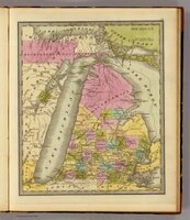 Michigan, 1840 A 1840 map of Michigan highlighting the recently acquired land to United States from the treaty of Washington D.C. in pink at the top.
 -
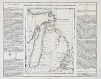 Michigan Territory, 1822 A 1822 map of Michigan highlingitng the seeatled areas of Michigan and the new border line running through Michigan between the United States territory and the indigenous tribes after the treaty of Chicago.
 -
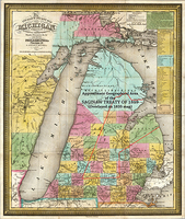 Michigan, 1835 A 1835 map of Michigan with red outline of the boundaries for the treaty of Saginaw.
 -
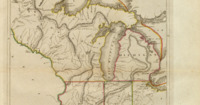 The Upper Territories of the United States, 1814 A 1814 map showing the early Midwest of the United states. Michigan, Indiana, Illinois and Wisconsin were territories at the time.