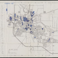
Map of Ann Arbor, Michigan
Item
of 1
- Title
- Map of Ann Arbor, Michigan
- Description
- This is a map of Ann Arbor, Michigan from the files of former city mayor, Cecil O. Creal with annotations from an unknown person or collective. The blue highlighted regions indicate areas important to discussions about fair housing in the city, which mostly consist of areas on the north side of Ann Arbor.
- Creator(s) of the Record
- Ann Arbor Chamber of Commerce
- Annotation Creator
- Unknown
- Date
- circa 1962-1963
- Medium
- Paper
- Type
- Map
- Subject
- Mapping Housing Discrimination
- Rights
- This digitized copy is generously provided for research purposes by the Bentley Historical Library, the institution charged with overseeing the care of the original document. Copyright for this document is held by the Regents of the University of Michigan.
- Rights Holder
- Regents of the University of Michigan
- Source
- Cecil O. Creal Papers: 1958-1968
- Bibliographic Citation
- Cecil O. Creal Papers, Box 4, Bentley Historical Library, University of Michigan, Ann Arbor, MI.
