-
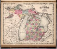 Michigan, 1859
 A 1859 map of Michigan that shows the established boarders for Michigan that stay relatively the same up to the present time.
-
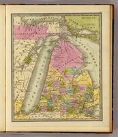 Michigan, 1840
 A 1840 map of Michigan highlighting the recently acquired land to United States from the treaty of Washington D.C. in pink at the top.
-
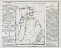 Michigan Territory, 1822
 A 1822 map of Michigan highlingitng the seeatled areas of Michigan and the new border line running through Michigan between the United States territory and the indigenous tribes after the treaty of Chicago.
-
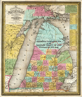 Michigan, 1835
 A 1835 map of Michigan with red outline of the boundaries for the treaty of Saginaw.
-
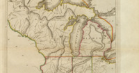 The Upper Territories of the United States, 1814
 A 1814 map showing the early Midwest of the United states. Michigan, Indiana, Illinois and Wisconsin were territories at the time.
-
 Treaty of La Pointe
 A treaty between the United States and the Chippewa nation. Signed October 4, 1842, in La Point, Wisconsin by Robert Straut commissioner on the part of the United States and representatives of the Ojibwe Bands of Lake Superior and the Mississippi River. The Ojibwe ceded an extensive amount of land which included the western part of Michigan’s upper peninsula and parts of northern Wisconsin. The treaty promised the bands money, services, and school, Additionally the treaty allowed hunting and fishing rights on the ceded land.
-
 Treaty of Washington D.C.
 A treaty between the United States and the Ottawa and Chippewa nations. Signed March 28, 1836, in Washington D.C. by the Indian Commissioner for the United States Henry Schoolcraft and representatives from the tribes. The tribes ceded almost fourteen million acres of land which encompassed the northwestern lower peninsula and eastern part of the upper peninsulas in Michigan. The treaty established permanent reservations and gave the tribes money, services, and the right to fish and hunt. This is the largest amount of land that tribes have ever ceded in a treaty.
-
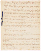 Treaty of Chicago
 A treaty between the United States and the Chippewa, Ottawa, and Potawatomi nations. Signed August 29, 1821, in chicago, Illinois by territorial governor of Michigan Lewis Cass, US house representative Solomon Sibley and representatives of each tribe. The tribes ceded all lands in Michigan south of the grand river and land in Indiana and Illinois on the southern coast of lake Michigan. Almost four million acres of land was ceded to the US. Signed by Lewis Class, territorial governor of Michigan. The treaty established small reservation boundaries in return for annuities and resources.
-
 Michigan. (with) Northwest part of Michigan
 This early map of Michigan post-statehood shows the aftermath of the Toledo War.
-
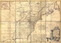 A Map of the British and French dominions in North America
 This map, created in 1755 by John Mitchell, was widely used as the basis for drawing new state boundaries until the first half of the 19th century. It was also the basis for the boundary dispute between Ohio and Michigan because the locations of Toledo and the mouth of the Maumee River were inaccurate.
-
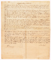 Treaty of Saginaw
 Also known as the Treaty with the Chippewa, it was an agreement between the United States and the Chippewa, Ottawa, and Potawatomi tribes. Signed September 24 1819, in Sagninwa Michigan. The tribes ceded six million acres of land which encompassed much of the central and eastern lower peninsula of Michigan. Signed by Lewis Cass, territorial governor of Michigan. The treaty promised that the US government would pay $1000 every year forever to the tribes and hunting and fishing rights on the land. The US government also promised blacksmiths and tools for farming. Additionally Several smaller tracts of land for tribal use within the ceded territory was also stated in the treaty.
-
 1775 Michigan and Ohio Relative Positions
 Map showing relative positions of Michigan and Ohio territories in 1775.
-
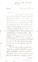 Letter detailing Stevens Thomas Mason's decisions regarding Ohio's claim to Toledo.
 Letter from unknown source discussing Stevens Thomas Mason's possible actions in response to Toledo's claim to Ohio. The writer discusses advice from President Andrew Jackson.
-
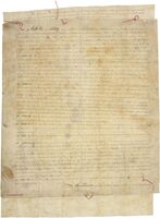 Treaty of Detroit
 In 1807, the Chippewa Nation, Citizen Potawatomi Nation, Gaaching Ziibi Daawaa Anishinaabe, and Wyandot of Anderdon Nation ceded millions of acres of land to Ohio and Michigan. In exchange, the four designated tribes only received $10,000 collectively. After the treaty was signed, their lands in the area were reduced to reservation lands between 1 and 6 square miles.
-
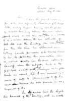 Handwritten letter from Lewis Cass to Stevens Thomas Mason, May 9, 1835
 Letter from Lewis Cass to Michigan governor Stevens Thomas Mason detailing Ohio's claim to Toledo.
-
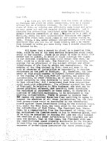 Typed letter from Lewis Cass to Stevens Thomas Mason, May 9, 1835
 Typed letter from Lewis Cass to Stevens Thomas Mason detailing the suspected dispute with Ohio over their claim of Toledo. Cass calls on Mason to ask for presidential intervention in the issue.
-
 Logo (MI Land Changes)
 logo
-
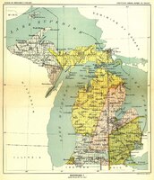 Map of all Treaties in Michigan
-
 Pic to Test
 Michigan, 1859 A 1859 map of Michigan that shows the established boarders for Michigan that stay relatively the same up to the present time.
 Michigan, 1840 A 1840 map of Michigan highlighting the recently acquired land to United States from the treaty of Washington D.C. in pink at the top.
 Michigan Territory, 1822 A 1822 map of Michigan highlingitng the seeatled areas of Michigan and the new border line running through Michigan between the United States territory and the indigenous tribes after the treaty of Chicago.
 Michigan, 1835 A 1835 map of Michigan with red outline of the boundaries for the treaty of Saginaw.
 The Upper Territories of the United States, 1814 A 1814 map showing the early Midwest of the United states. Michigan, Indiana, Illinois and Wisconsin were territories at the time.
 Treaty of La Pointe A treaty between the United States and the Chippewa nation. Signed October 4, 1842, in La Point, Wisconsin by Robert Straut commissioner on the part of the United States and representatives of the Ojibwe Bands of Lake Superior and the Mississippi River. The Ojibwe ceded an extensive amount of land which included the western part of Michigan’s upper peninsula and parts of northern Wisconsin. The treaty promised the bands money, services, and school, Additionally the treaty allowed hunting and fishing rights on the ceded land.
 Treaty of Washington D.C. A treaty between the United States and the Ottawa and Chippewa nations. Signed March 28, 1836, in Washington D.C. by the Indian Commissioner for the United States Henry Schoolcraft and representatives from the tribes. The tribes ceded almost fourteen million acres of land which encompassed the northwestern lower peninsula and eastern part of the upper peninsulas in Michigan. The treaty established permanent reservations and gave the tribes money, services, and the right to fish and hunt. This is the largest amount of land that tribes have ever ceded in a treaty.
 Treaty of Chicago A treaty between the United States and the Chippewa, Ottawa, and Potawatomi nations. Signed August 29, 1821, in chicago, Illinois by territorial governor of Michigan Lewis Cass, US house representative Solomon Sibley and representatives of each tribe. The tribes ceded all lands in Michigan south of the grand river and land in Indiana and Illinois on the southern coast of lake Michigan. Almost four million acres of land was ceded to the US. Signed by Lewis Class, territorial governor of Michigan. The treaty established small reservation boundaries in return for annuities and resources.
 Michigan. (with) Northwest part of Michigan This early map of Michigan post-statehood shows the aftermath of the Toledo War.
 A Map of the British and French dominions in North America This map, created in 1755 by John Mitchell, was widely used as the basis for drawing new state boundaries until the first half of the 19th century. It was also the basis for the boundary dispute between Ohio and Michigan because the locations of Toledo and the mouth of the Maumee River were inaccurate.
 Treaty of Saginaw Also known as the Treaty with the Chippewa, it was an agreement between the United States and the Chippewa, Ottawa, and Potawatomi tribes. Signed September 24 1819, in Sagninwa Michigan. The tribes ceded six million acres of land which encompassed much of the central and eastern lower peninsula of Michigan. Signed by Lewis Cass, territorial governor of Michigan. The treaty promised that the US government would pay $1000 every year forever to the tribes and hunting and fishing rights on the land. The US government also promised blacksmiths and tools for farming. Additionally Several smaller tracts of land for tribal use within the ceded territory was also stated in the treaty.
 1775 Michigan and Ohio Relative Positions Map showing relative positions of Michigan and Ohio territories in 1775.
 Letter detailing Stevens Thomas Mason's decisions regarding Ohio's claim to Toledo. Letter from unknown source discussing Stevens Thomas Mason's possible actions in response to Toledo's claim to Ohio. The writer discusses advice from President Andrew Jackson.
 Treaty of Detroit In 1807, the Chippewa Nation, Citizen Potawatomi Nation, Gaaching Ziibi Daawaa Anishinaabe, and Wyandot of Anderdon Nation ceded millions of acres of land to Ohio and Michigan. In exchange, the four designated tribes only received $10,000 collectively. After the treaty was signed, their lands in the area were reduced to reservation lands between 1 and 6 square miles.
 Handwritten letter from Lewis Cass to Stevens Thomas Mason, May 9, 1835 Letter from Lewis Cass to Michigan governor Stevens Thomas Mason detailing Ohio's claim to Toledo.
 Typed letter from Lewis Cass to Stevens Thomas Mason, May 9, 1835 Typed letter from Lewis Cass to Stevens Thomas Mason detailing the suspected dispute with Ohio over their claim of Toledo. Cass calls on Mason to ask for presidential intervention in the issue.
 Logo (MI Land Changes) logo
 Map of all Treaties in Michigan
  Pic to Test